")
")

Victoria Falls
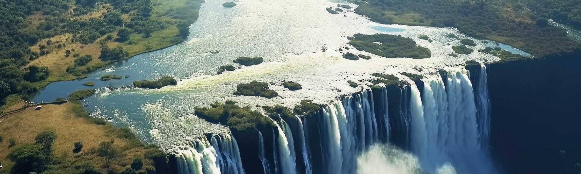
The Victoria Falls are the biggest waterfalls in Africa, situated in the mighty Zambezi River, the fourth largest African river system. The Vic Falls (local name Mosi-oa-Tunya: "The smoke that thunders") are located at the border between Zambia and Zimbabwe.
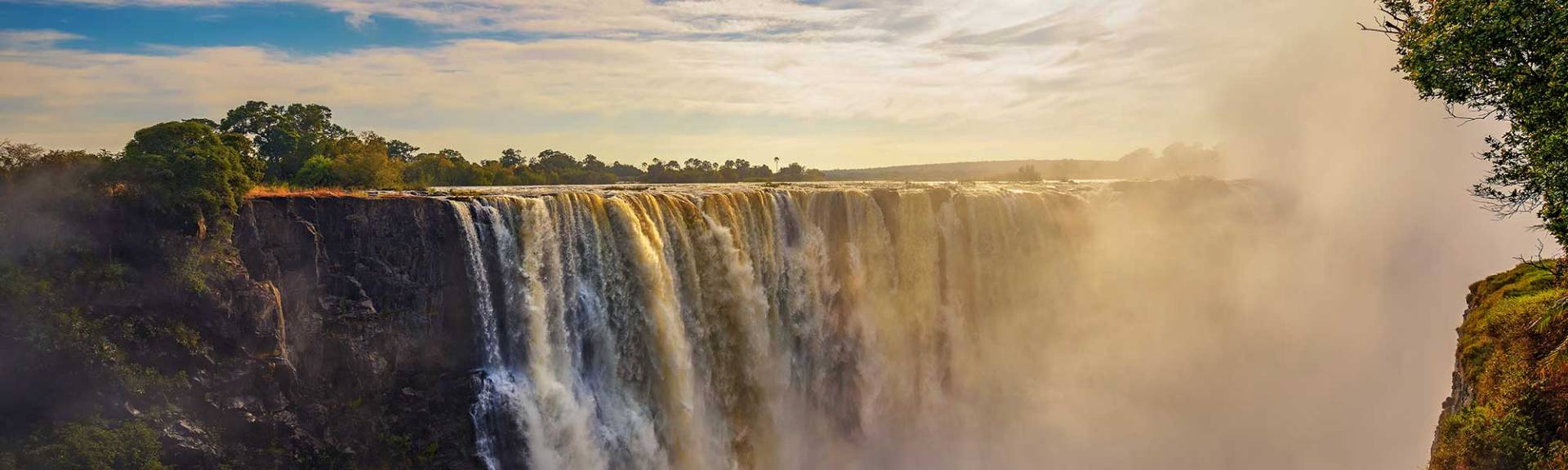
With a width of about 1700m and a height of 108m, the Victoria Falls are not the widest and highest waterfalls, but due to the inconsistent rainfall in the area, they are the waterfall with the greatest fluctuation in the amount of water they carry.
At its lowest waterflow in November and December, less than 20 000m³ of water passes over the falls per minute. At peak flow in March and April it is over 500 000m³ of water that passes over the falls per minute. During this time the spray shoots some 400m high and can be seen from a distance as far as 40km.
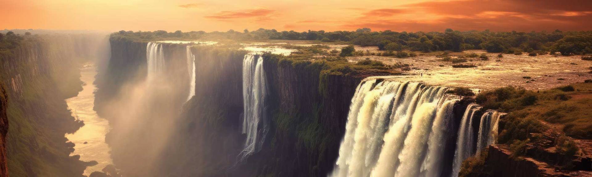
The immense falls are broken up by small islands which stand on the lip of the falls. One of them is called Livingstone Island, from where David Livingstone viewed the falls first. From east to west these are the Eastern Cataract, the Rainbow Falls, the Horseshoe Falls, the Main Falls, and the Devils Cataract. Around the falls on both sides of the river are rainforests which are sustained by the constant spray of mist from the falls. Plants that grow here are rarely found elsewhere in Zimbabwe and Zambia.
Map of the Victoria Falls
History of the Victoria Falls
The great and world-famous Victoria Falls were named in 1855 by David Livingstone in honor of the British Queen Victoria. Obviously the Victoria Falls were well known to the local people long before they were ‘discovered’ by the first Europeans. They were called ‘Shongwe’ by the Tokaleya and ‘aManza Thunqayo’ by the Ndebele. Today they are also known by their Makololo name "Mosi-oa-Tunya" which means ‘The smote that thunders’.
Livingstone was the first known European to see the falls and, in his honor, the Zambian Town "Livingstone", which is close to the waterfalls carries his name. A statue was also unveiled on the Zimbabwean side of the falls, near the Devil’s Cataract, although he never viewed the falls from the Zimbabwean side and in fact never set a foot on Zimbabwean soil.

Geological history of Victoria Falls
To understand the geological history of Victoria Falls, one must understand the geological processes over the past millions of years. The most dominant rock formation in the Victoria Falls area is basalt, which formed from about 180 million years onwards, when gentle volcanic eruptions laid down layers of lava. Each successive layer of lava covered the solidified layer before it, forming a 300m thick basalt rock island in the surrounding sandveld. This basalt rock stretches for about 200km from Kazangula in Botswana to the Batoka Gorge east of Victoria Falls. As the lava solidified, cracks or joints emerged, mostly in an east-west direction.
About 110 million years ago the Gondwana Continent started to break up, which caused a deepening of the cracks or joints. The cracks were gradually filled with material, which was much softer than the surrounding basalt. Also, the breakup of Gondwana caused a gradual upliftment of the emerging Southern Africa, which altered the old river systems and creating new ones. In the old river system, Victoria Falls did not exist and the upper and lower Zambezi were not linked. The old river systems included rivers like the upper Zambezi, together with the Okavango and other rivers, which flowed over what is now known as the Kalahari into the prehistoric Limpopo River, which ended in the Indian Ocean. The prehistoric lower Zambezi and its tributaries entered the Indian Ocean separately further north.
Tectonic movements and upliftment some 10-15 million years ago eventually led to a combination of the old upper and lower Zambezi, flowing from north to south over the basalt outcrops with its’ cracks, filled with softer material. The huge amounts of water eroded the softer material away, forming the waterfalls and the gorges which can be seen today: The Victoria Waterfalls.
Due to erosion, the Victoria Waterfall cuts its way backwards into the rock, slowly opening up the cracks and creating new gorges. Arial photographs clearly show the many gorges that were formed in the past million years and also where new gorges will most probably emerge in future. The present Victoria Falls are between 100 000 and 250 000 years old.
Importance of the Victoria Falls
The Victoria Falls are of immense economic importance for both Zimbabwe and Zambia. The beautiful Victoria falls give the whole region an immense tourism potential. They are the biggest falls in Africa, are being classified as one of the seven natural wonders of the world and are also a UNESCO World Heritage site. Furthermore the surrounding areas with it's natural environment, the mighty Zambezi River and a couple of national parks with their wealth in African Game species (not only the Big Five) add onto the value for tourism. Over a million visitors visit the Falls every year.
Touristic highlights at Victoria Falls
There are hundreds of touristic activities that visitors of the Victoria Falls can book with the many activity operators, both on the Zimbabwean and on the Zambian side of the Falls. Among the most popular are visiting the Victoria Falls, white water rafting, bungee jumping, boat cruises, safaris into the close-by National parks, scenic flights and so on.
Here you will find an overview page of Victoria Falls activities
Economic importance of the Zambezi River and Victoria Falls
The Zambezi River also has a tremendous economic potential for both Zimbabwe and Zambia. With an average vertical drop of about 92m, the Victoria Falls have an enormous hydroelectric potential. It is for this reason, that already in the early 20th century, plans were made to utilize this enormous potential by a hydroelectric powerplant at Victoria Falls, but fortunately never materialized. A small hydroelectric plant is however in existence on the Zambian side of the falls. Not completely off the table are more recent plans of building two hydroelectric powerplants some 50km east of Victoria Falls, each with a capacity of 1200MW, one for the Zambian side, one for the Zimbabwean side. The dam, which will supply the water to the plant will have a 181m high wall, meaning the water of this dam could back up to within 650m of Victoria Falls, a UNESCO World Heritage Site, contravening the UNESCO restrictions. A project like this would cause serious harm to the tourism industry, destroying thousands of jobs.
Victoria Falls bridge
The towns of Victoria Falls and Livingstone are also an important rail and road junction between Zimbabwe and Zambia, thanks to the famous bridge over the Zambezi. The Victoria Falls bridge was commissioned in 1900 by Cecil Rhodes. He insisted that the bridge would be built in a way that the spray from the Fall covers the train as it crosses. Works began in the middle of 1903. The bridge was built from both sides simultaneously and was completed in April 1905. As early as 1948 the upper, wide Zambezi River near Victoria Falls was also an important stopover for international flights between South Africa and the UK. The flying boat service used to land their planes en-route from the Vaal Dam near Johannesburg to Southampton, operated by the BOAC and South African Airways.